Pieljekaise National Park - Jäckvik and top of Bieljijgáse
Climbing to the ''Ear Peaks'' from Jäckvik, the highest point of Pieljekaise National Park, with stunning 360° views and a trail full of birch forests, streams, and reindeer.
A Quiet Morning in Jäckvik
The morning in Jäckvik was calm when I woke up in the van parked at the dedicated Kungsleden parking area. It was my second time visiting Pieljekaise National Park, but this time I approached it from the Jäckvik side. A few days earlier, I’d entered from Adolfström, which led me to Lake Luvtávrre - beautiful, but nothing compared to what awaited me today.
With my dog Vizze trotting ahead, we set out on the trail. The plan was to hike up to the park’s highest peak, Bieljijgáse - 1138 meters above sea level - and back.

The trail began in a birch forest.
Into the Forest and Beyond
The trail began in a birch forest. The first couple of 100 meters were quite flat, but after a while, the path climbed steadily, crossing small creeks that provided fresh, cold water almost all the way up to the peak.
The first stretch was quite steep. After approximately 1-1,5 hours hike, the forest opened up and the slope eased slightly.

There was a cabin just before the forest ended. Where hikers could stay over night and rest.

Entering an open landscape.
The closer I got to the peak, the steeper the climb. I tend to walk too fast, so I had to stop and catch my breath a couple of times before finding my pace. And every time I turned around, the view just got better. On one side of the valley - orange och looking like fall - and on the other side - green and looking like summer.

This picture is taken on the way down and shows the orange part of the landscape i the front, and the green part of the landscape in the back. Like experiencing both summer and fall at the same time.

This picture is taken at the peak and shows the green part of the landscape that I mentioned in the post.

Mountain view. Picture taken from the trail.
The Top of Bieljijgáse

Vizze admiring the view from the peak.
After about 2-3 hours, we reached the summit. Up here, the world opened up in all directions. Mountains stretched out on every side and all you could hear was the wind. A small stone pile stood on the peak where other hikers who had been on the summit had added a rock to contribute, and to it, I added one of my own.

A happy Lovisa at the peak.
Vizze, tired after the long climb, struggled to keep his eyes open, so he curled up for a nap, which gave me time to enjoy a much longed-for coffee and sandwich. Before heading back down, I walked around the peak, taking photos from different angles and soaking in the 360° view.

A tired Vizze ready to take a nap when we had reached the top.
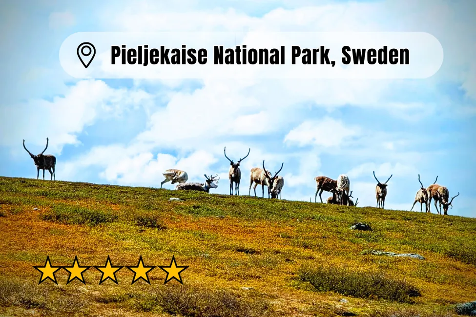
On the way down, I took a slightly different route and spotted a reindeer antler in the stream. It had some algae on it, so I cleaned it and brought it with me as a souvenir. Further down, we even came across a small herd of reindeer. They were quite shy and kept their distance, but I managed to snap a few pictures while Vizze was buzzing with excitement.

On the way down from we met some reindeers.
Comparing the Two Trails
Having hiked both from Adolfström and Jäckvik, I can honestly say the route from Jäckvik is the best of the two. The climb is more demanding (about 700 vertical meters), but the views from the top are absolutely worth it. Both hikes took about 5–6 hours round trip (you can, of course, go for longer hikes if you want to), but the summit experience from Jäckvik felt more rewarding.
Facts about Pieljekaise National Park
📍 Location: Pieljekaise National Park, Lapland, Sweden
🏔️ Highest point: Bieljijgáse, 1138 m
👂 Name of highest peak: Bieljijgáse, which means “Ear Peaks” in Sami, since the two summits resemble ears in profile
⬆️ Elevation gain from Jäckvik: ~700 meters
🚶♀️ Trail: Part of the Kungsleden, then a detour to the peak
⏳ Distance: Day hike, about 6 hours round trip
🅿️ Parking: At the Kungsleden parking lot in Jäckvik
🏠 Accommodation on the trail: There is a small cabin partway up where you can stay overnight
Good to Know & Tips
⛰️ The trail is steep in many parts and is quite challenging
🌬️ Bring windproof clothes, a hat, or a headband for the summit. If you get sweaty, it gets cold quickly
💧 Plenty of streams along the way, so no need to carry too much water
🐕 If you bring a dog, keep it leashed around wildlife
👀 Take time to turn around on the way up - the view behind you changes constantly
📷 Walking slightly off the main path near the top gives you new angles of the landscape
🌦️ The weather at the top can change quickly - plan accordingly
Reflection
Standing on top of Bieljijgáse, this hike reminded me that sometimes the hardest climbs reward you with the most unforgettable views. If you’re thinking about visiting Pieljekaise, I highly recommend taking the trail from Jäckvik - it’s a day you won’t forget. And remember to look back now and then to see how the view keeps getting better and better the closer you get to the peak.
As a last picture in this post, I have added the trail I took to the peak. It is not a route you can choose on the app AllTrails (yet), but the trail is clearly visable. It's also well marked when you hike it, so you won't have any difficulties finding your way. Shortly after ''Allmän Raststuga'' (that shows on the map), you take left instead of right.

The green line is the trail that takes you to the peak.
